 INTECMAR Catalogue
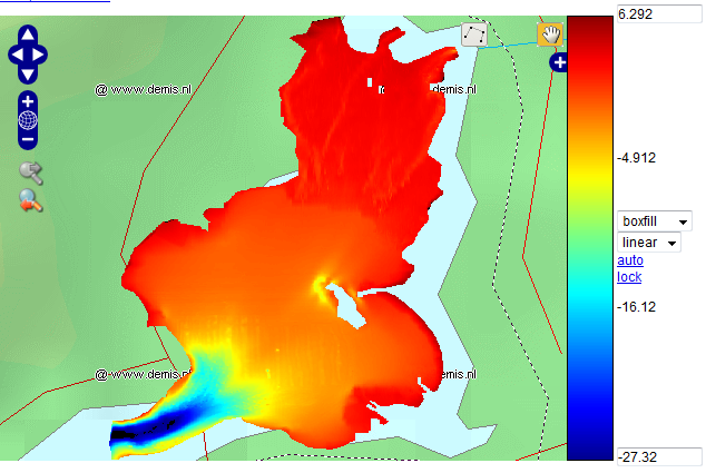
Batimetría de la Ensenada de San Simón
Batimetría de la Enseada de San Simón (Ría de Vigo) en una malla de 10x10 m de resolución, a partir de sondeos, llegando también a las zonas intermareales. Las profundidades están referidas al NMMA.
Formato de archivo en NetCDF en sistema de referencia EPSG:23029 (UTM29N ED50).
|
|
Citation proposal
. Batimetría de la Ensenada de San Simón. http://xeocatalogo.intecmar.gal/geonetwork/srv/api/records/GLG_INTECMAR_BATIMETRIA_SANSIMON_2014 |
INSPIRE
Identification
- File identifier
- GLG_INTECMAR_BATIMETRIA_SANSIMON_2014 XML
- Hierarchy level
- Dataset
Online resource
- Protocol
- OGC:WMS-1.3.0-http-get-map
Resource identifier
- Metadata language
- Spanish; Castilian
- Spatial representation type
- Grid
Encoding
- Format
- SHP - ArcView ShapeFile
- Version
- Versión 9.3
- Specification
Projection
Classification of data and services
- Topic category
-
- Elevation
Classification of data and services
Coupled resource
Coupled resource
Classification of data and services
Coupled resource
Coupled resource
Keywords
- GEMET - INSPIRE themes, version 1.0 ( Theme )
-
- Elevaciones
- European Territorial Units ( Place )
-
- ESPAÑA
- Galicia
- Vigo
- GCMD ( Theme )
-
- OCEANOGRAFÍA
- BATIMETRÍA
- MARC21 - Vocabulario controlado ( Theme )
-
- Relieve
- Batimetría/Isogramas
- Tesauro de la UNESCO ( Theme )
-
- CIENCIA
- GEOGRAFÍA Y OCEANOGRAFÍA
- OCEANOGRAFÍA
- INVESTIGACIÓN OCEANOGRÁFICA
- BATIMETRÍA
- CARTA BATIMÉTRICA
Other keywords
Geographic coverage
))
Temporal reference
Temporal extent
Temporal extent
- Date ( Creation )
- 2014-02-27
Quality and validity
- Lineage
-
Datos recogidos por Cartogalicia a partir de una ecosonda SONIC 2024 Broadband Multibeam Echosounder durante Febrero y Marzo de 2012, a partir de un contrato con el INTECMAR. Los datos se interpolaron a una malla de 10x10 m y se referenciaron al NMMA (Nivel 0 del IGN), usando como transformación Nivel 0 del Puerto de Vigo= NMMA -1.772 m. Finalmente, se pasó de la da malla ascii a netCDF en INTECMAR.
Este desarrollo ha sido financiado por el Proyecto RAIACO (Interreg POCTEP Galicia-Norte de Portugal – 0520_RAIA_CO_1_E (2012-2015)).
- Denominator
- 10
Conformity
Conformity
Conformity
Conformity
Conformity
Conformity
- Explanation
- Consultar el reglamento mencionado
Restrictions on access and use
- Access constraints
- Se permite cualquier uso si se menciona la autoría del INTECMAR.
Restrictions on access and use
Responsible organization (s)
Contact for the resource
- Organisation name
- Instituto Tecnolóxico para o Control do Medio Mariño de Galicia
- gis@intecmar.gal
Responsible organization (s)
Contact for the resource
- Organisation name
- Instituto Tecnolóxico para o Control do Medio Mariño de Galicia
- gis@intecmar.gal
Metadata information
Contact for the metadata
- Organisation name
- Instituto Tecnolóxico para o Control do Medio Mariño de Galicia
- gis@intecmar.gal
- Date stamp
- 2025-10-09T15:37:12
- Metadata language
- Spanish; Castilian
- Character set
- UTF8
SDS
Conformance class 1: invocable
Access Point URL
Endpoint URL
Technical specification
Conformance class 2: interoperable
Coordinate reference system
Quality of Service
Access constraints
Limitation
Use constraints
Limitation
Responsible custodian
Contact for the resource
Conformance class 3: harmonized
Overviews
Provided by
